William Bacon's Homepages/World Information Page (Earthquakes & Volcanic activity)


Locations of Site Visitors

Comments?????
Email the Webmaster!!!!!


This page was last updated on February 23, 2026


William Bacon's World Information Page
(Earthquakes & Volcanic activity) Page Index


INTRODUCTION

Status of the Deep Space Network

Information on Status of the Deep Space Network

About the Deep Space Network: Space Communications and Navigation

Information on About the Deep Space Network: Space Communications and Navigation

NASA's Digital Orrery

MAST: Barbara A. Mikulski Archive for Space Telescopes

Information on MAST: Barbara A. Mikulski Archive for Space Telescopes


Map of the Universe from Johns Hopkins University and others.....

Johns Hopkins University (JHU) continues to pad its space community résumé with their interactive map, “The map of the observable Universe”, that takes viewers on a 13.7-billion-year-old tour of the cosmos from the present to the moments after the Big Bang. While JHU is responsible for creating the site, additional contributions were made by NASA, the European Space Agency, the National Science Foundation, and the Sloan Foundation.

JWST's weekly observing schedule:

NASA's Unverse of Learning
An Integrated AstroPhisics STEM Learning and Literacy program

The Solar Ham


Click here to return to top of page


WORLD INFORMATION


Day and Night World Map

Information on Day and Night World Map

Latest quakes worldwide in the past 24 hours

Information on Latest quakes worldwide in the past 24 hours

Volcano Discovery

Currently active volcanoes in the world
Source: VolcanoDiscovery

Global Earthquake Response Center

The Earth's Tectonic Plates

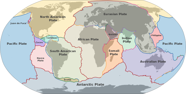
Plate tectonics (from Latin tectonicus, from Ancient Greek τεκτονικός (tektonikós) 'pertaining to building')[1] is the scientific theory that Earth's lithosphere comprises a number of large tectonic plates, which have been slowly moving since about 3.4 billion years ago.[2] The model builds on the concept of continental drift, an idea developed during the first decades of the 20th century. Plate tectonics came to be accepted by geoscientists after seafloor spreading was validated in the mid-to-late 1960s.

From Wikipedia The Earth's Tectonic Plates


Click here for a
Google "Mashup" of a day/night Clock of the world

And here for
NASA's World Wind simulator

P>

Windy.com & Multiple world Information

Information on Windy.com

Here is Earth's Gravity ...


And here for
GLOBE (Global Learning and Observations to Benefit the Environment) is
a worldwide hands-on, primary and secondary school-based science and
education program.

Here for
Population media news about world population


Click Here To Return to Top of Page


The latest real time earthquake report:


Information on The latest real time earthquake report:

The Earth master


Information on Earth master's youtube channel

(Keep chat clean and appropriate please) Check out the new EM Store. Live Earthquake updates. Live Space weather events Earthquake Activity in Iceland New!! Earthmaster merch Live Earthquake updates. Live Seismic data.. Current World Earthquake Map . Recent California and Nevada Earthquakes Current Space Weather info

Earthquakes in 3D

Information on Earthquakes in 3D

GSN Heliplots

Information on GSN Heliplots

Interactive Map of Active Volcanoes and recent Earthquakes world-wide

The United States Geological service's earth quake map

Information on The United States Geological service's earth quake map

Global Quake.net

Information on Global Quake.net

Earth scope- seismic Monitor

eartquakes world wide


Click here to return to top of page


Regional Seismographs

Yellowstone National park seismographs

Centre Sismologique Euro-Méditerranéen Euro-Mediterranean Seismological Centre

Seismographs New Zealand

Information on Seismographs New Zealand

PNSN-The Pacific Northwest sesmic network

Information on PNSN-The Pacific Northwest sesmic network

Map of Earthquakes in Alaska

Earthquake Activity in Iceland


Information on Earthquake Activity in Iceland

Earthquake Activity in Hawaii

Information on Earthquake Activity in Hawaii


Earthquakes Canada

New Zealand Volcanic alert level summary

Information on New Zealand Volcanic alert level summary

Phillipines: PHIVOLCS LATEST EARTHQUAKE INFORMATION

Institute of Geodynamics Hellenic (Greek) Seismetic Netowk-


Click Here To Return to Top of Page


SPACEWEATHER

Spaceweather.com

The Solar Ham


Information on The Solar Ham


AURORA Alert

Heaves above.com

Earth Sky Calculus

Information on Earth to Sky Calculus' Facebook page


Click here to return to top of page


Tsunami !!!!!!!!!!!

US Government Tsunami warning system

Information on US Government Tsunami warning system

USGS Reveals Why Offshore Faults Pose a Greater Tsunami Risk

In this video, we go beneath the Pacific to the offshore fault networks that can trigger tsunamis with little warning— and why many of these systems are still poorly constrained. We explain how USGS and NOAA combine seafloor sensors, satellites, and advanced simulations to model tsunami generation, arrival times, and inland inundation. We dive into the real danger: cascading ruptures where one fault slip loads another, potentially amplifying wave heights and shrinking evacuation windows. Finally, we show why “models aren’t predictions”—and why preparedness depends on adapting fast as new offshore data redraws what “safe” really means. 00:00 Intro 02:47 Unseen Origins of Tsunami Threat 05:57 The Science of Tsunami Generation 09:26 When Faults Collide: Modeling the Chain Reactions 12:28 The Modelers’ Dilemma: Limits, Insights, and the Pressure to Predict 15:13 Early Warning in the Age of Real-Time Data: Progress and Pitfalls 18:11 What We Know, What We Don’t, and the Price of Assumptions 21:01 The Right Question 22:05 Where Models and Memory Collide 26:36 Outro For business or copyright matters, please contact: beciomedia(at)gmail.com Fair Use Disclaimer: Our videos do not negatively affect the original works. We produce videos for instructional purposes. Our videos are transformative in nature. We only use the audio part and very short video clips if necessary Copyright Disclaimer under section 107 of the Copyright Act 1976, allowance is made for “fair use” for purposes such as criticism, comment, news reporting, teaching, scholarship, education, and research. Fair use is a use permitted by copyright statutes that might otherwise be infringing. This channel is based on facts, rumors & fiction. 🎬Subscribe for new videos:/ @earthtube_official


Click here to return to top of page


Smithsonian Institute National Museum
of Natural History Global Volcanism Program

Latest Volcanic Ash Advisory Center (VAAC) reports

Information on Latest Volcanic Ash Advisory Center (VAAC) reports


Some World Services


Here is Satellite view of the earth from the GEOS 8 Satellite Click here!!!


Here is False color image (near real time)


Here is B&W Imge near real time


For weather click here for Weather.com


Here is the national weather service's Official weather site


Here is a great page for Space weather !!!


Here is CNN's weather page


For something else that affects the environment here is US Geologicalsurvey


Or click here for Environmental News Network


Here is the enviroinmental site for Commonwealth of Pennsylvania's Official environmental web site


Here is the Commonwealth of Pennsylvania's Clean PA Forests.org


Here is the Discovery Channel's Earth Alert page


Click here For EARTH Portal


And here for Pyra form -- a new way of living

This page is for Noaa's home page


This page for Space weather!!


This is a subpage for NOAA Space Envirnment Center of Noaa


Here for a graphic version National Weather Service


Weather forecast for Area 51!!


Another map is Radar Loop for the US!


Yet another weather page: The Wxusa page!

Tropical tidbits.com

Information on Tropical tidbits.com


Click Here To Return to Top of Page